


Are you looking for printable maps and other resources
to help plan your visit to Stillwater?
We’ve gathered many of the most popular in one place.
These resources vary from video walking tours to parking maps,
all with the intention of helping you have as much information as possible to make your trip to Stillwater a wonderful one!

Stillwater Steps Route: The historic Stillwater Steps are a popular walking tour of Stillwater. You probably know where a couple of sets of steps are but do you know where all five are located? This is the route to take if you would like to see all five sets and the great history along the way.

Visitor’s Guide: The ultimate resource for visitors to Stillwater. This guide has the restaurant, boutique, and attractions listings as well as a fold-out map of historic downtown and a re-print of the historic walking tour downtown. We will happily mail visitor’s guides to you!

Visitor Guide Parking Map: This map will tell you what you need to know for the best parking options in Stillwater. Watch for the parking ramp and the 24 hour parking locations for some of the best options. For an extended map, view/print the black & white tear-off map with hotel area as well as downtown.
 Homes Tour (video): This is a set of videos you can watch on your smart phone that will lead you on a historic walking tour of the gorgeous historic homes in Stillwater. Pick the loop you want to visit and use the accompanying video to help learn about the history of the homes you see.

Downtown Tour (video): Another video tour that will give you wonderful history and insight into what you are seeing in downtown Stillwater. The “Birthplace of MN” is a gem of a town full of historic buildings, beautiful landscapes, fun boutiques, great things to do, and delicious restaurants. Watch and learn about what you are experiencing as you walk along.
City Trails Maps – Stillwater and Oak Park Heights: A convenient map of all the trails for walking or biking located in town.
 Brown’s Creek Nature Preserve Trails Map: This is a great little spot for cross country skiing in the winter or a summer walk and has Brown’s Creek bike trail access.
Pike Point Park CC Trails Map: A map of the Cross Country skiing trails in Pike Point Park which is also where you can jump on the Gateway State Trail.
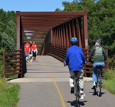
Gateway/Brown Creek’s Trail Map: This popular bike trail is absolutely stunning! Grab a map to plan your route and parking locations. Don’t forget to stop off in Stillwater for a bite to eat.
 River City Sculpture Tour Map: Find 12 original sculptures throughout downtown Stillwater as part of a multi-city free public art tour.
St. Croix Scenic Byway Route Map : Meander along the St. Croix River roads from Point Douglas, MN to north of Hinkley, MN. Check out the Historical Travel Guide for route ideas and stories! Sawmill District central section features Stillwater. For fall colors, drive from Stillwater to Taylor’s Falls!
![]()
![]()
![]()